Blog 4 | June 22, 2019
By: Marta Arjona, PhD student at Institute for Marine Sciences, Barcelona
Effect of trawling on particle transport in canyons
Hey deep sea-explorers!! I am Marta, a PhD student from the Institute of Marine Sciences (CSIC) in Barcelona (Spain), doing an internship at the NIOZ. My research mainly focuses on the study of sedimentary dynamics in Mediterranean submarine canyons associated with deep-sea trawling activities. Beside natural processes, the disturbance of the deep-sea in the Mediterranean by this fishing technique is considered to be notably higher than all other anthropogenic pressures combined, given its intensity, recurrence and wide geographical distribution. Although its impacts on coastal and shallower environments have been investigated in the past from a geological point of view, only very few studies have addressed the role of deep-sea trawling in submarine canyons, where background energy levels controlling natural sedimentary processes are normally low and where the associated faunal communities are less resilient and more vulnerable.
Therefore, my main goal is to understand the contemporary sedimentary processes that tend to occur in submarine canyons driven by this anthropogenic activity. To accomplish this, during my thesis project I have joined many cruises in which I have been recording time series of currents, suspended sediment concentrations and particle fluxes by several mooring deployments nearby heavily trawled sites. Since my work is related to submarine canyons, I’m here on the R/V Pelagia to improve my knowledge of sedimentary processes, and gain insight into other canyon systems in comparison to the Mediterranean submarine canyons. On this cruise I’m working with some amazing researchers and crew and I will be helping out with various types of sampling techniques and analyses, and with the knowledge I gain here I hope to improve my own research.
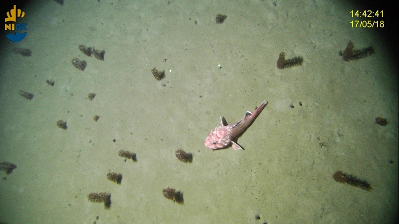
Blog 3 | June 21, 2019
By: Grace English, Irish Observer with the Marine Institute, Ireland
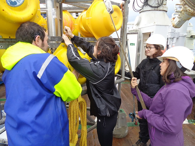
Box core
As this research survey is taking place on the Whittard Canyon, in Irish waters, there is a role available for an Irish Observer on board. Under the United Nations Convention on Laws of the Sea (UNCLOS), the observer acts as a representative of the state and prepares a summary cruise report. It is also an opportunity for young researchers to gain practical experience on board a research vessel and gain experience with new techniques.
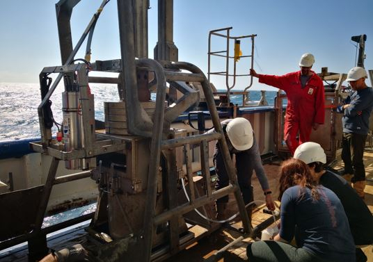
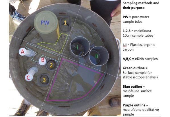
As the Irish Observer with the Marine Institute, Ireland on board, I helped wherever I was needed during sampling. I found it amazing the variety and amount of different samples that can be taken from the same source. For example, the box core, a geological sampling tool which is deployed to get a soft sediment sample of the seafloor surface. From these box cores we get an image of the composition and inhabitants of the sea floor.
When the box core arrives back on deck, first the water needs to be siphoned off to reveal the sediment core. Some of this water is saved for filtering so that the suspended sediment can be tested for microbial and environmental DNA. Before all the water is removed, a tube with small holes at centimetre intervals along the side (taped tightly!) takes a saturated sample so that the pore water can be examined.
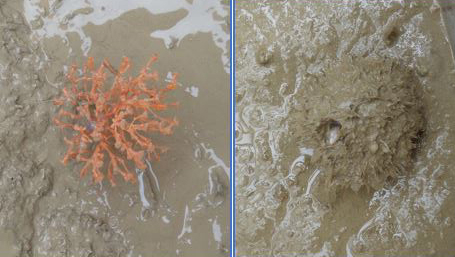
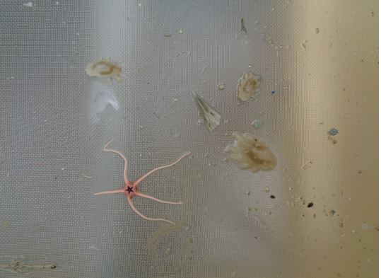
The water can then be removed, and a picture taken of the underlying sediment. This can be an exciting moment as the last of the water is siphoned off to potentially reveal a macrofauna species lying on the surface. Ophiuroids, soft corals and sponges have all been found this cruise!
The sediment type and colour are recorded and then the core is divided into four roughly equal parts so that one quarter can be reserved for sieving the macrofauna as a qualitative sample. The box core is then sampled for meiofauna, stable isotope analysis, plastics, and organic carbon. The remaining sediment is sieved through a 0.5mm sieve to gather the rest of the macrofauna living inside the sediment as a quantitative sample.
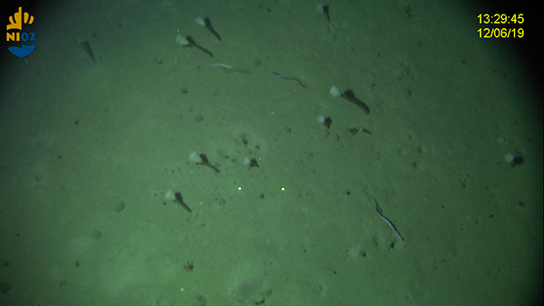
Blog 2 | June 20, 2019
By: Aike Vonk, Master student at Utrecht University
Secrets of Whittard Canyon, the premiere
Not only in the evening we watch movies at the Pelagia, but also some of our daylight hours are spent behind the tv screen. We, researchers on the Pelagia, do not watch the newest Avengers movie, or the thrilling James Bond series, what we see is way more exciting... We discover the slopes of Whittard Canyon.
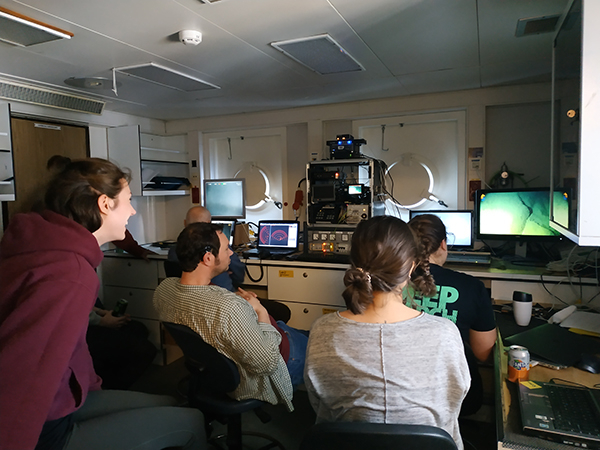
The research conducted at Whittard Canyon takes place in the deep sea, about 200-4000 meters under the sea surface. Because of the large depths in the Canyon, it is often unknown what the sea floor looks like. To find out, we use video images. A frame with two camera’s is led down over the side of the ship until it is a few meters above the sea floor. One camera faces downwards and films the ocean floor; the other camera faces forward. On this camera we can see if steep flanks arise and whether or not the camera should be taken back up. Because we look at the deep parts of the Canyon, it can take over 40 minutes before the camera reaches the bottom of the ocean.
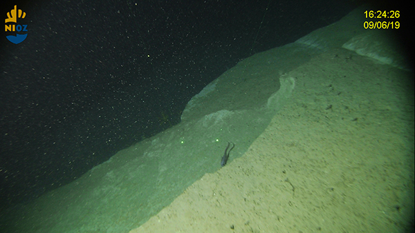
Once the ocean floor appears on screen, we feel like adventurers. Parts of our earth are exposed that no one else has ever seen before! If you think that the only images we see are boring sand flats, you could not be more wrong. When the ship moves through the ocean, the ocean floor changes from impressive mountain landscapes with large blocks of stone and steep slopes of tens of meters high, to flat sand bottoms inhabiting all kinds of animals, like sponges and corals. The video images are used to investigate fauna distribution and density, but also to look at the topography of the ocean floor. Based on the video footage it is determined which parts of the Whittard Canyon are suitable for sampling and which parts of the sea floor are too rough.
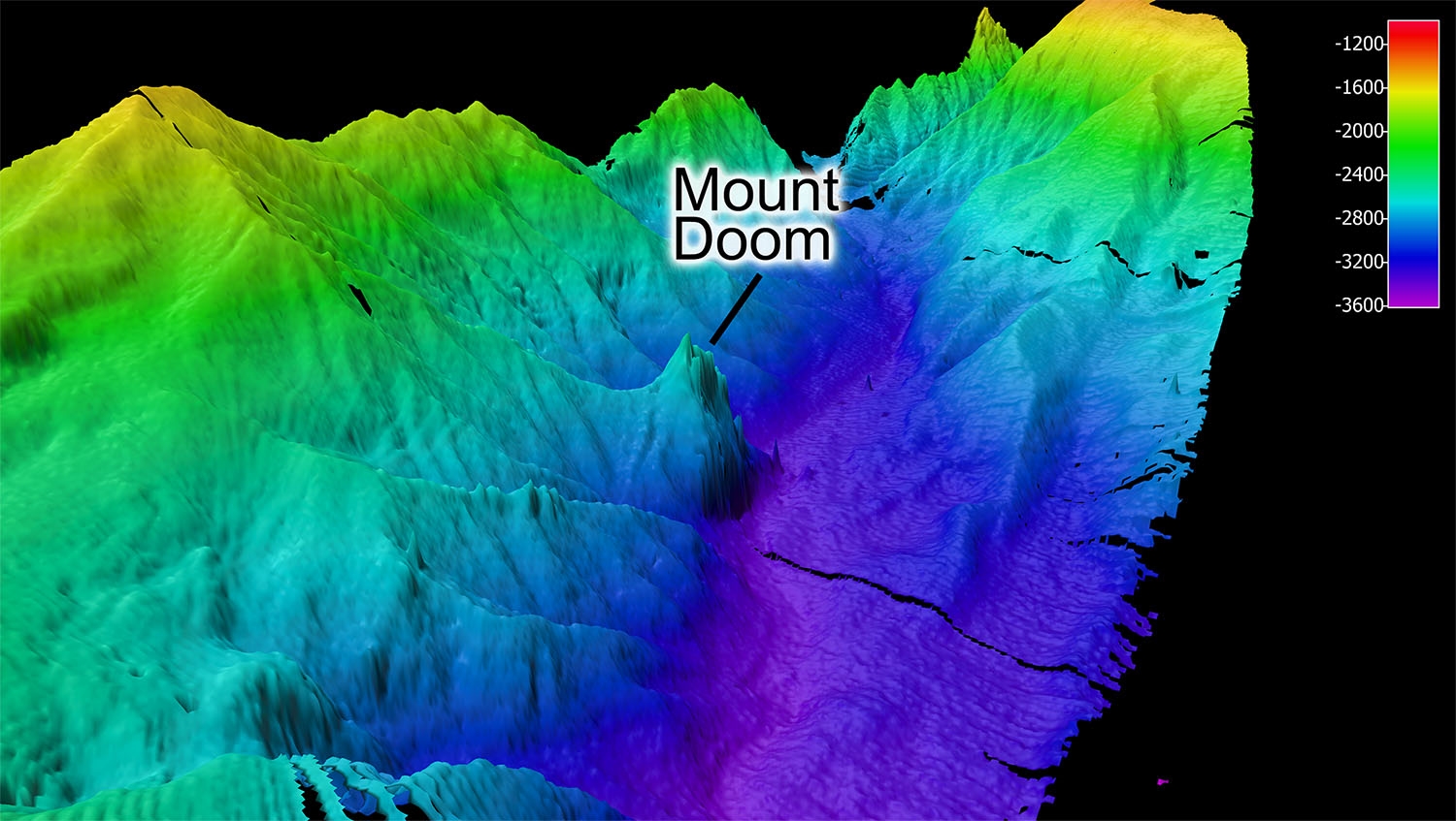
Blog 1 | June 18, 2019
by Andy Davies, University of Rhode Island
Exploring Mount Doom
As part of BYPASS 2019, we are exploring the Whittard Canyon, a highly active canyon system south of Ireland. One of our activities is to complete a comprehensive multibeam map of the system, filling in areas that we collected on previous research cruises in 2017 and 2018. We’ve already made some interesting discoveries, foremost, a pinnacle at 2500 m water depth that we have informally named “Mount Doom”, which is approximately 800 m high from the bottom of the Canyon. This outcrop is likely exposed rock, potentially an old volcano and may contain abundant marine life. This mystery will only be solved when we send down a camera.
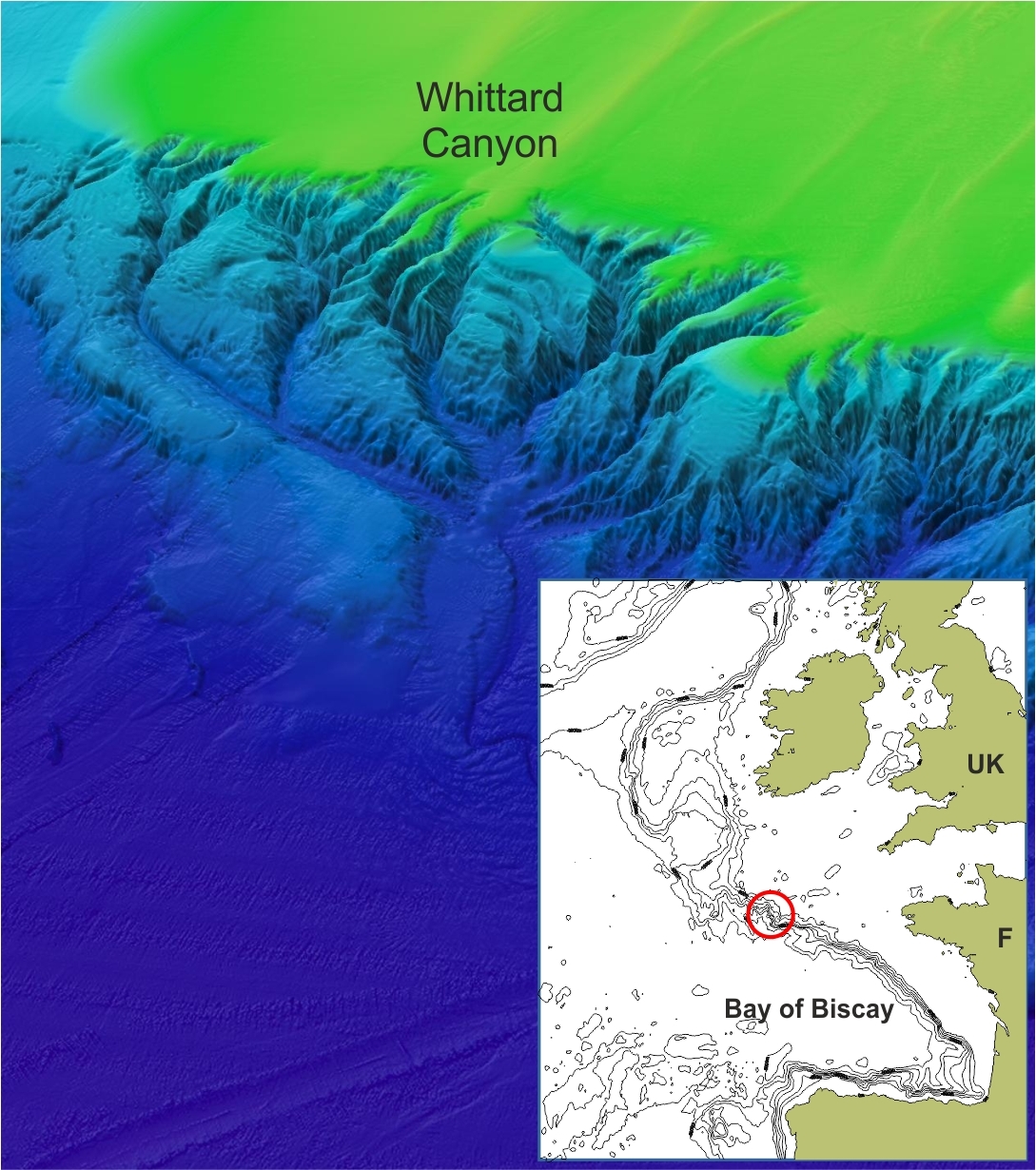
Introduction | June 18, 2019
by Furu Mienis
The mysteries and secrets of Whittard Canyon
After three days of transit we have arrived at the Whittard Canyon complex in the Bay of Biscay. The Whittard Canyon complex has 4 major branches which run from 200 to over 4000 m water depth. The morphology of Whittard Canyon is comparable to canyon systems on land, like the Grand Canyon with the main difference that this canyon system lies completely underwater. Canyons form important transport channels for material from shallow to deep water, hereby connecting the productive shelf with the food limited deep-sea. We would like to understand how much and how often material is transported through the canyon and where this material is deposited. We are mainly interested in the transport of carbon since canyons might form important pathways for carbon transport to the deep-sea. If this carbon gets buried in the deep-sea it will be no longer part of the carbon cycle, which in the end might affect global climate. Transport of particles can be a constant process but can also be linked to episodes. Data collected in the canyon during previous cruises have shown that for instance storms hitting the shelf result in events whereby large amounts of material are transported. These events occur several times a year. In addition the carbon is also an important food source for deep-sea fauna, like cold-water corals, sponges, but also large numbers of fish. During this cruise we will study the distribution and density of fauna and we will see if we can link their occurrence to abiotic factors, like temperature, food supply and morphology of the canyon.
 Furu Mienis
 Lorendz Boom
 Sander Asjes