Drowned land of the Scheldt Delta
Visualising historic, natural landscapes
Many people are nowadays used to a landscape that is heavily modified by humans. Dykes separate the marine realm from the terrestrial world. On one side of the dyke, the land is dominated by intensive agriculture homogenising the landscape. On the other side, tidal flats and marshes - if present at all - are squeezed by the direct or indirect impact of shipping in many human-modified estuaries. Modification of the landscape, in the marine as well as in the terrestrial realm, has had dramatic effects on coastal ecosystems, lowering their ability to follow sea level rise, decreasing biodiversity.
Despite the loss of the coastal natural landscape, restoration is often difficult to realise, mainly because knowledge and appreciation of how these landscape once looked like has disappeared from societal memory. At NIOZ, we develop novel 3D visualisation techniques that build on the latest ecological models to depict how coastal ecosystems once looked like, and may look like in the future. With our models, we can describe the complexity of salt marsh creeks, the patterning of mussel beds, and the fractal-like heterogeniety created by grazing. Building on these models we reveal and build appreciation of the historic landscapes with their high biodiversity that once covered our land and sea.
Historic landscapes of the Scheldt Delta
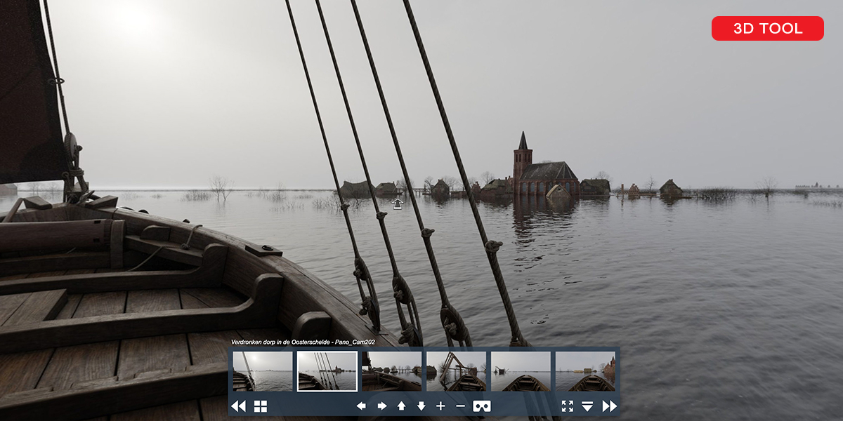
An example project where we utilise these techniques is the 'Drowned land of the Scheldt Delta' project, where we visualise the landscape and human inhabitants of area that is now the 'Drowned land of Reimerswaal'. In the past centuries many Zeeuwse villages have been lost during and after storm floods. This has led to the characteristic Zeelandic phenomenon of the drowned villages, remains of human houses on the tidal flats of the Scheldt estuary. Flooding often led to an economic decline of the communities because local agricultural productivity collapsed. Because of the floods, the land around the village changed from an agricultural area to a tidal landscape.
In collaboration with Provincie Zeeland, we are currently developing a virtual tour of the changes that occur during the ‘drowning’ of a village in the 16th century. The virtual tour will be based on 3D visualizations of the landscape and the village before and after the flood. We plan to present our visualisation on November 5 2021, on the date of the dreaded 'Quade Saterdach' (Bad Saturday), but you can already look at the trailer and have a first peek here (click the red 3D tool button in the image).
The virtual tour is developed in collaboration with the Unesco Global Geopark, Schelde Delta as part of the communication to stakeholders and the general public. The project is financed by Corona subsidy of Samenwerkende Maritieme Fondsen (SMF), with contributions from the Province of Zeeland and the Municipality of Reimerswaal.