Decades of dredging are pushing the Dutch Western Scheldt Estuary beyond its ecological limits
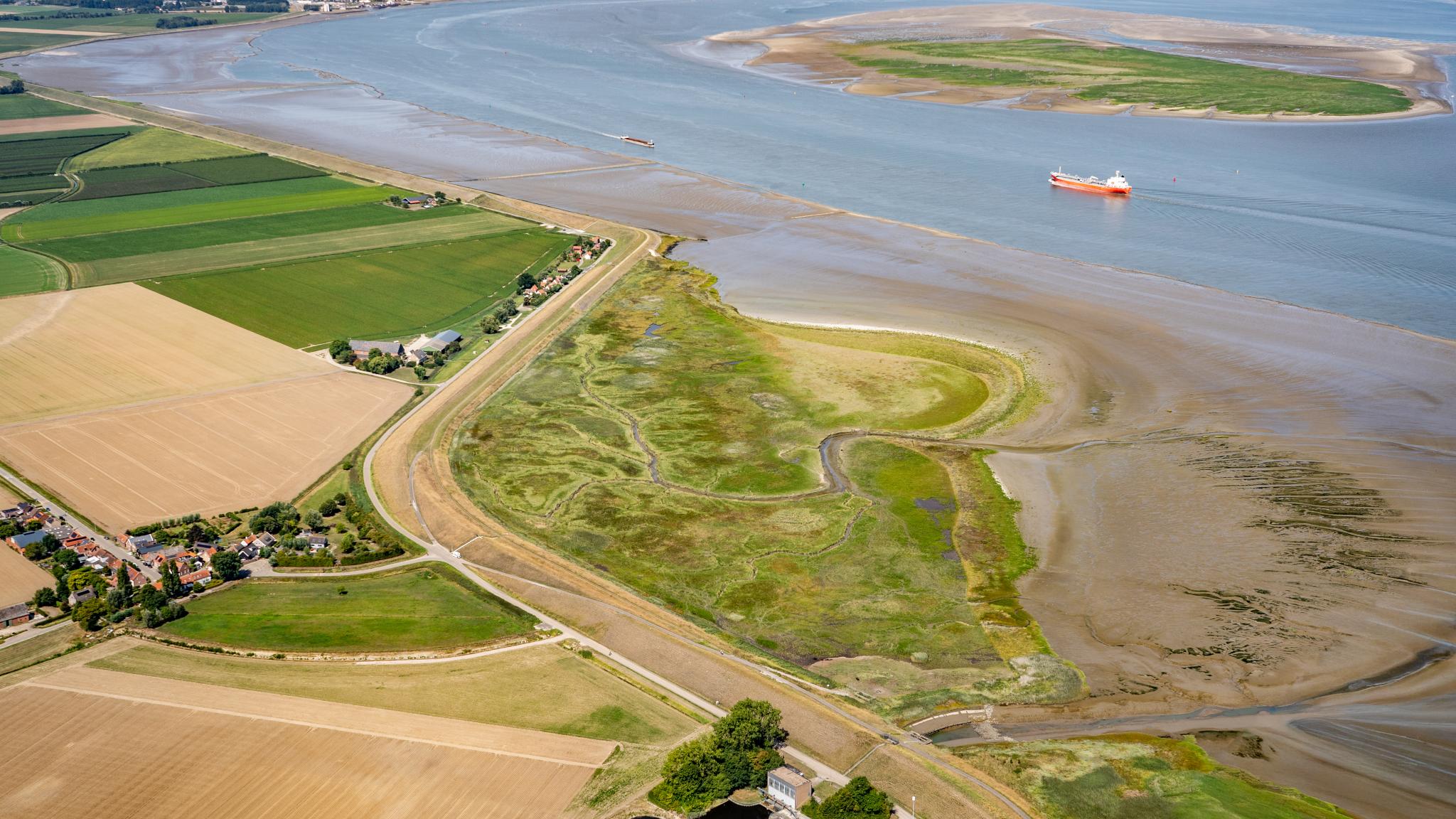
Salt marsh, mud flat and and waterway in the Western Scheldt (credit: Edwin Paree)
The Dutch Western Scheldt Estuary has been pushed onto an unsustainable trajectory since large-scale navigation channel deepening began in the 1970s. The dramatic increase in the annual volume of dredged sediment from the navigation channel has reduced feeding grounds for birds and made the estuary more vulnerable to sea-level rise. This is shown by the Dutch report De Westerscheldenatuur: Een mooie toekomst vraagt keuzes nu!. Dutch and Flemish researchers call on policymakers to use dredged sediment strategically for nature restoration and climate adaptation.
After analysing nearly seventy years of monitoring data from the Dutch water authority (Rijkswaterstaat), researchers from NIOZ, the University of Antwerp and Utrecht University found that the once diverse mosaic of mudflats, sandbars and tidal channels in the Western Scheldt is gradually being replaced by a more uniform and increasingly vegetated landscape, with less space for open intertidal flats and shallow channels. “This trend occurs throughout the entire estuary,” says NIOZ researcher Tim Grandjean. “We see a structural shift that leads to a major loss of ecological value.”
Disposal of dredged material disrupts the balance
To maintain access to the Port of Antwerp, one of Europe’s largest ports located in Belgium upstream of the estuary, the main shipping channel of the Western Scheldt has been deepened and widened three times since the 1970s. As a result, annual maintenance dredging has increased sharply, from less than 0.5 million m³ before 1950 to 7–10 million m³ per year today. This material is removed from the channel and disposed of elsewhere in the Western Scheldt.
The analyses show that the choice of where this dredged sand and silt are disposed of has a major impact on nature. Due to the annual dredging operations, unvegetated mudflats receive large pulses of fine sediment. Where large volumes of dredged sediment are deposited, the bed level rises more quickly. Elevated mudflats are flooded less frequently, which allows vegetation to establish.
Equilibrium between mudflats and salt marshes
The Western Scheldt is mostly dominated by two types of intertidal habitats: unvegetated mudflats and vegetated salt marshes, which together form the intertidal environment. The bare mudflats of the Western Scheldt are among the most productive ecosystems in Western Europe. They are crucial for migratory birds and seals, while the salt marshes contribute to flood safety by attenuating waves and protecting the coast. The interaction between mudflats and marshes is essential. Marshes are able to keep pace with sea-level rise because tidal action and vegetation trap sediment from the mudflats.
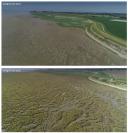
Within one year this mudflat became saltmarsh (credit: Jeroen van Dalen)
Human interventions in the Western Scheldt have disrupted the balance between mudflats and salt marshes. Since 1996, approximately 500 hectares of mudflat have been lost as a result of dredging and sediment disposal and largely converted into higher-elevation salt marshes. This places the ecological values of the Western Scheldt under pressure: the loss of mudflats reduces habitat for large numbers of migratory birds and other characteristic species. Moreover, the expansion of salt marshes leads to increasing sediment fixation, whereas dynamic erosion and sedimentation are crucial for maintaining biodiversity in the Western Scheldt.
Policy choices are urgently needed
According to the researchers, policymakers must make clear decisions as soon as possible to prevent further degradation of the Western Scheldt’s. “Stopping dredging is not an option – navigation channel maintenance remains essential,” Grandjean emphasises. “But how we handle the dredged sediment will determine how the Western Scheldt develops in the future.”
Restoration targets not being met
The Western Scheldt has a defined ecological restoration target of at least 3,000 hectares, to compensate from historical land reclamation, embankment, channel deepening and intensive dredging. This target is aimed specifically at restoring dynamic intertidal habitats, particularly mudflats and pioneer marshes, in order to bring the estuary back to a favourable conservation status. Over the past two decades, only about 600 hectares have been realised within the Western Scheldt. At the same time, around 500 hectares of mudflats transitioned into higher salt marshes, largely offsetting the intended gain of mudflat and pioneer-marsh habitat, even though the total area of nature has not declined.
Sediment availability also offers opportunities
At the same time, the increased availability of sediment also offers opportunities. Sediment can be used as a strategic building material for climate adaptation, flood protection and nature development. Fine sediments, for example, can be valuable in low-lying dike zones along the estuary, where they are needed to make the landscape more resilient and better able to keep pace with sea-level rise. “The Western Scheldt is at a tipping point,” Grandjean concludes. “Let us use the sediment we are moving today to build a robust and future-proof estuary for the next generations of Zeeland.”
Linked staff
Tim Grandjean
Postdoc

Jim van Belzen
Senior Scientist

Tjeerd Bouma
Senior Research Leader

The report
Grandjean, T.J., van Belzen, J., Fivash, G.S., Temmerman, S., Kleinhans, M.G. & Bouma, T.J., (2026). De Westerscheldenatuur: Een mooie toekomst vraagt keuzes nu! NIOZ Report 2026-01. NIOZ Royal Netherlands Institute for Sea Research: 36 pp.
The report