
- Remote sensing, Earth Observation and Geo-Information Science; Big Data
- Coastal, estuarine & delta systems
- Geomorphology, biogeomorphology, biophysical interactions & benthic ecology
- Nature based flood defence & ecosystem based solutions
- Aquatic systems and water quality
Prof. Dr. Daphne van der Wal
View on the coast
Daphne van der Wal – physical geographer at NIOZ and professor at the University of Twente – observes deltas, coasts and estuaries from space and from the air. ‘That can be done via satellites but also with the help of drones. The use of these remote sensing techniques can teach us a lot about coastal defence, water quality and nature conservation.’
Protection against storms
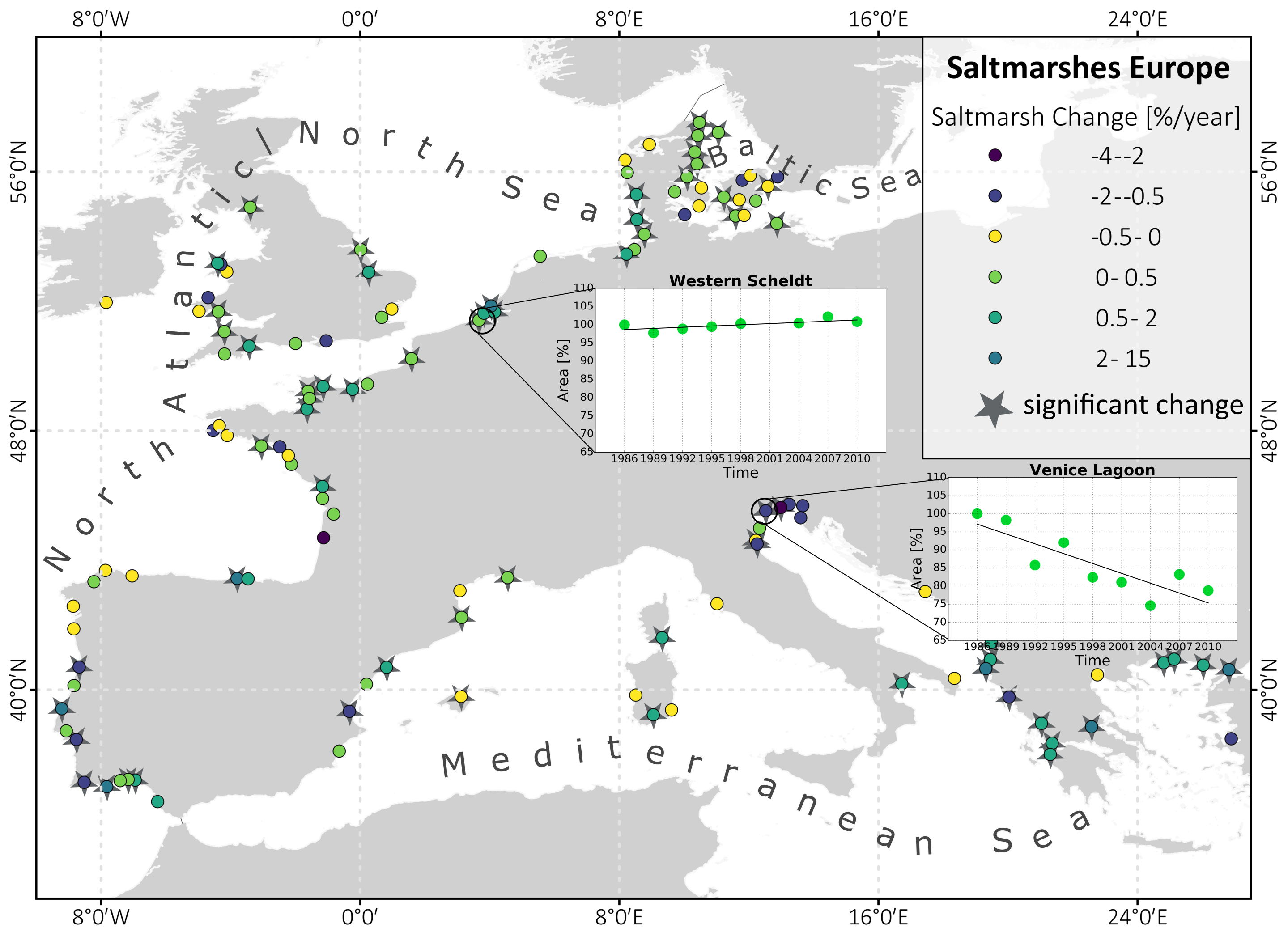
‘Satellites have the advantage that, in many cases, they allow us to look back over several decades. This is because we have a long history of satellite images which have continually observed a piece of the Earth’s surface in the same way. For example, from satellite images, we can see where coastal vegetation, such as saltmarshes and mangroves, has expanded and where plants have disappeared or where their growth was hampered. We analyse satellite images in relation to coastal protection for the Dutch coast, but also for the coast of Louisiana, for example. Together with modellers, we are examining how vegetation attenuate the waves and trap sediments and can reduce the chance of the land becoming flooded during heavy storms. That allows us to learn what the ingredients are for sufficiently strong coastal defences. Such information is becoming increasingly relevant in light of the changing climate and expected increase in extreme weather.
Looking at muddy waters
‘Satellite images are also well suited for studying the quality of the water and the seabed. For example, we examine the interaction between sediment and the algae and animals that live in the water and seabed. This knowledge is important with respect to, for example, the dredging of estuaries for shipping.’
Radar seeks mussel reef
‘We also use radar images; these can observe, for example, the roughness of tidal mudflats. This way, radar can even be used to map mussel and oyster reefs on tidal mudflats. Now we can also make use of techniques like drones. These provide very detailed spatial information.
With all these forms of remote sensing, we are finding out how our coastal systems work and how they adapt to changing conditions and interventions. We are also learning how coastal processes help us, and how we can protect our coasts.’
Read more +
Specialisation & Current positions
I am a physical geographer, specialized in coastal processes (PhD 1999, University of Amsterdam; postdoctoral research fellow from 1 Oct 1999 up to 1 Jan 2002 at Royal Holloway, University of London). In Mar 2002, I joined NIOO/NIOZ in Yerseke, focusing on remote sensing of tidal (eco)systems. Since Oct 2017, I am also part-time full professor at University of Twente, Faculty of Geo-Information Science and Earth Observation (ITC).
Publications can be found at my ORCID
Remote sensing of tidal (eco)systems
Theme
The central theme of my work is to assess interactions between organisms (such as saltmarshes, algae, shellfish) and their environment, shaping the estuarine, delta and coastal landscape, including both the bottom sediment and the water column. Topics also include the response of estuarine and delta systems to (climate) change and human impact, as well as risks (e.g., flooding) and services (e.g., nature-based flood risk reduction) of the coastal zone.
Current research topics
- Saltmarsh and mangrove development
- Solutions for nature-based flood defence
- Dynamics and management of (intertidal) sediments
- Structuring and functioning of benthic fauna communities
- Benthic-pelagic interactions in tidal systems
- Primary production of tidal flats and waters
- Suspended sediments and sediment transport in coastal waters
Methods & techniques
I use remote sensing techniques and geo-informatics to investigate coastal and estuarine systems and processes:
- statistical modelling, use of radiative transfer models, and big data analysis with remote sensing data (radar/SAR, optical and TIR satellite data, hyperspectral airborne/drone data and LIDAR airborne data, near-surface and field spectroscopy/measurements) for retrieval and forecasting
- spatial analyses in Geographical Information Systems (GIS)
- (time-series) analyses of remote sensing data using cloud platforms
- combination of earth observation with field surveys and experiments, and (hydrodynamic) models
Selected projects (at NIOZ)
- Output remote Sensing work package of a NWO NWA North Sea project on offshore wind parks. See article: Brandao et al (2023)
- Small contribution to NWO NWA small project, 2023, see here
- STW Perspective AllRisk – Implementing new flood safety norms. Project Foreshore Ecosystems Management. My role: co-applicant of project B (Dynamics in hydraulic loads). PhD candidate at NIOZ/RUG: Beatriz Marin Diaz (joint supervision NIOZ/RUG: Tjeerd Bouma, Han Olff, Laura Govers, Daphne van der Wal). See Beatriz' PhD thesis, and movie. See also the programme overview and programme outcome.
- NWO/NSO Ruimteonderzoek, “Saltmarshes under stress: thresholds for saltmarsh dynamics from global satellite data” (MARSH). See NWO project output.
- Satellite remote sensing of microphytobenthos in the Wadden Sea: analysis of 18 years of MODIS data , for Deltares, 2021.
- EU FP7 SPACE - FAST "Foreshore Assessment using Space Technology". Consortium Deltares, University of Cambridge, NIOZ Royal Netherlands Institute for Sea Research, University of Cadiz, GeoEcoMar. My role: work package leader WP3: Remote sensing. PhD candidate at NIOZ on this project: Bas Oteman, started 2014 . See Bas' PhD thesis. See also the overall project outcome.
- NWO/NSO Ruimteonderzoek: “Benthic diatoms as indicator for ecosystem structuring in shallow tidal waters. PhD candidate at NIOZ on this project Tisja Daggers, started 2013. See Tisja's PhD thesis.
- NWO/NSO Ruimteonderzoek: "Consequences of global change for ecosystem engineering of shellfish". PhD-candidate at NIOZ on this project Sil Nieuwhof, started 2012. See Sil's PhD thesis.
- Benthic invertebrates (macrofauna) of the shallow subtidal areas (van der Wal et al., 2017) and intertidal areas (van der Wal et al., 2017) of the Westerschelde estuary, for Rijkswaterstaat.
Features
Results from the NWO project Saltmarshes under stress
Laengner, M.L.; van der Wal, D. (2022). Satellite-derived trends in inundation frequency reveal the fate of saltmarshes. Frontiers in Marine Science 9, 942719. https://doi.org/10.3389/fmars.2022.942719
Laengner, M.L.; Siteur, K.; van der Wal, D. (2019). Trends in the seaward extent of saltmarshes across Europe from long-term satellite data. Remote Sensing 11(14), 1653. https://dx.doi.org/10.3390/rs11141653
Results from the EU FAST project
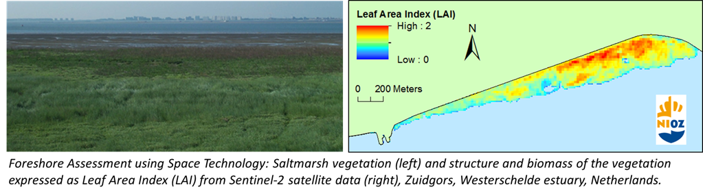
The EU FP7 project FAST (Foreshore Assessment using Space Technology), 2014-2018, has developed services to help design nature-based flood risk strategies in foreshores, based on earth observation data and big data analysis capabilities. The MI SAFE downstream service is currently not online anymore, but the data can be found here and the metadata can be found here.
Read more on EU FAST in the associated article on this Copernicus downstream service for coastal needs.
See the results of the EU FAST project in the project synthesis report "Earth Observation and the Coastal Zone, from global images to local information".
Take a tour around the Danube Delta in Romania, one of the field sites in the EU FAST project!
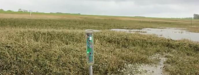
See our instructional videos on field techniques, for example on the use of sedimentation sensors, as used to assess lateral saltmarsh cliff erosion in Van der Wal et al. (2023), and vertical sedimentation/ erosion in Willemsen et al. (2018), Hu et al. (2018), Hu et al. (2017) and Hu et al. (2015).
Linked news
NIOZ publications
-
2023
Brandao, I.L.S.; van der Molen, J.; van der Wal, D. (2023). Effects of offshore wind farms on suspended particulate matter derived from satellite remote sensing. Sci. Total Environ. 866: 161114. https://dx.doi.org/10.1016/j.scitotenv.2022.161114de Liz Arcari, A.; Tavora, J.; van der Wal, D.; Salama, M.S. (2023). The Wastewater Contamination Index: A methodology to assess the risk of wastewater contamination from satellite-derived water quality indicators. Frontiers in Environmental Science 11: 1130655. https://dx.doi.org/10.3389/fenvs.2023.1130655Marín Díaz, B.; van der Wal, D.; Kaptein, L.; Martinez-Garcia, P.; Lashley, C.H.; de Jong, K.; Nieuwenhuis, J.W.; Govers, L.L.; Olff, H.; Bouma, T. (2023). Using salt marshes for coastal protection: Effective but hard to get where needed most. J. Appl. Ecol. 60(7): 1286-1301. https://dx.doi.org/10.1111/1365-2664.14413Nauta, J.; Christianen, M.J.A.; Temmink, R.J.M.; Fivash, G.S.; Marín Díaz, B.; Reijers, V.C.; Didderen, K.; Penning, E.; Borst, A.C.W.; Heusinkveld, J.H.T.; Zwarts, M.; Cruijsen, P.M.J.M.; Hijner, N.; Lengkeek, W.; Lamers, L.P.M.; van der Heide, T.; Bouma, T.J.; van der Wal, D.; Olff, H.; Govers, L.L. (2023). Biodegradable artificial reefs enhance food web complexity and biodiversity in an intertidal soft‐sediment ecosystem. J. Appl. Ecol. 60(3): 541-552. https://dx.doi.org/10.1111/1365-2664.14348
-
2022
Aranda, M.; Peralta, G.; Montes, J.; Gracia, F.J.; Fivash, G.S.; Bouma, T.J.; van der Wal, D. (2022). Salt marsh fragmentation in a mesotidal estuary: Implications for medium to long-term management. Sci. Total Environ. 846: 157410. https://dx.doi.org/10.1016/j.scitotenv.2022.157410Laengner, M.L.; van der Wal, D. (2022). Satellite-derived trends in inundation frequency reveal the fate of saltmarshes. Front. Mar. Sci. 9: 942719. https://dx.doi.org/10.3389/fmars.2022.942719Marín Díaz, B.; Govers, L.L.; van der Wal, D.; Olff, H.; Bouma, T.J. (2022). The importance of marshes providing soil stabilization to resist fast‐flow erosion in case of a dike breach. Ecol. Appl. 32(6): e2622. https://dx.doi.org/10.1002/eap.2622
-
2021
Gijsman, R.; Horstman, E.M.; van der Wal, D.; Friess, D.A.; Swales, A.; Wijnberg, K.M. (2021). Nature-based engineering: a review on reducing coastal flood risk with mangroves. Front. Mar. Sci. 8: 702412. https://dx.doi.org/10.3389/fmars.2021.702412Hu, Z.; Willemsen, P.W.J.M.; Borsje, B.W.; Wang, C.; Wang, H.; van der Wal, D.; Zhu, Z.; Oteman, B.; Vuik, V.; Evans, B.; Möller, I.; Belliard, J.-P.; Van Braeckel, A.; Temmerman, S.; Bouma, T.J. (2021). Synchronized high-resolution bed-level change and biophysical data from 10 marsh–mudflat sites in northwestern Europe. ESSD 13(2): 405-416. https://dx.doi.org/10.5194/essd-13-405-2021Marín Díaz, B.; Fivash, G.S.; Nauta, J.; Temmink, R.J.M.; Hijner, N.; Reijers, V.C; Cruijsen, P.M.J.M.; Didderen, K.; Heusinkveld, J.H.T.; Penning, E.; Maldonado-Garcia, G.; van Belzen, J.; de Smit, J.C.; Christianen, M.J.A.; van der Heide, T.; van der Wal, D.; Olff, H.; Bouma, T.J.; Govers, L.L. (2021). On the use of large-scale biodegradable artificial reefs for intertidal foreshore stabilization. Ecol. Eng. 170: 106354. https://dx.doi.org/10.1016/j.ecoleng.2021.106354Marin-Diaz, B.; Govers, L.L.; van der Wal, D.; Olff, H.; Bouma, T.J. (2021). How grazing management can maximize erosion resistance of salt marshes. J. Appl. Ecol. 58(7): 1533-1544. https://doi.org/10.1111/1365-2664.13888Oteman, B.; Scrieciu, A.; Bouma, T.J.; Stanica, A.; van der Wal, D. (2021). Indicators of expansion and retreat of Phragmites based on optical and radar satellite remote sensing: a case study on the Danube delta. Wetlands 41(6): 72. https://dx.doi.org/10.1007/s13157-021-01466-xvan de Vijsel, R.C.; van Belzen, J.; Bouma, T.J.; van der Wal, D.; van de Koppel, J. (2021). Algal‐induced biogeomorphic feedbacks lay the groundwork for coastal wetland development. JGR: Biogeosciences 126(10): e2021JG006515. https://dx.doi.org/10.1029/2021jg006515
-
2020
Arabi, B.; Salama, M.S.; van der Wal, D.; Pitarch, J.; Verhoef, W. (2020). The impact of sea bottom effects on the retrieval of water constituent concentrations from MERIS and OLCI images in shallow tidal waters supported by radiative transfer modeling. Remote Sens. Environ. 237: 111596. https://dx.doi.org/10.1016/j.rse.2019.111596Cornacchia, L.; Wharton, G.; Davies, G.; Grabowski, R.C.; Temmerman, S.; van der Wal, D.; Bouma, T.J.; van de Koppel, J. (2020). Self-organization of river vegetation leads to emergent buffering of river flows and water levels. Proc., Sect. B Biol. Sci. 287(1931): 20201147. https://doi.org/10.1098/rspb.2020.1147Daggers, T.D.; Herman, P.M.J.; van der Wal, D. (2020). Seasonal and spatial variability in patchiness of microphytobenthos on intertidal flats from sentinel-2 satellite imagery. Front. Mar. Sci. 7: 392. https://dx.doi.org/10.3389/fmars.2020.00392Daggers, T.D.; van Oevelen, D.; Herman, P.M.J.; Boschker, H.T.S.; van der Wal, D. (2020). Spatial variability in macrofaunal diet composition and grazing pressure on microphytobenthos in intertidal areas. Limnol. Oceanogr. 65(11): 2819-2834. https://dx.doi.org/10.1002/lno.11554Jiang, L,; Gerkema, T.; Kromkamp, J.; van der Wal, D.; Carrasco de la Cruz, P.M.; Soetaert, K. (2020). Drivers of the spatial phytoplankton gradient in estuarine–coastal systems: generic implications of a case study in a Dutch tidal bay. Biogeosciences 17(16): 4135-4152. https://dx.doi.org/10.5194/bg-17-4135-2020van Bijsterveldt, C.E.J.; van Wesenbeeck, B.K.; van der Wal, D.; Afiati, N.; Pribadi, R.; Brown, B.; Bouma, T.J. (2020). How to restore mangroves for greenbelt creation along eroding coasts with abandoned aquaculture ponds. Est., Coast. and Shelf Sci. 235: 106576. https://dx.doi.org/10.1016/j.ecss.2019.106576van de Vijsel, R.C.; van Belzen, J.; Bouma, T.J.; van der Wal, D.; Cusseddu, V.; Purkis, S.J.; Rietkerk, M.; van de Koppel, J. (2020). Estuarine biofilm patterns: modern analogues for Precambrian self‐organization. Earth Surf. Process. Landforms 45(5): 1141-1154. https://dx.doi.org/10.1002/esp.4783
-
2019
Cornacchia, L.; Folkard, A.; Davies, G.; Grabowski, R.C.; van de Koppel, J.; van der Wal, D.; Wharton, G.; Puijalon, S.; Bouma, T.J. (2019). Plants face the flow in V formation: A study of plant patch alignment in streams. Limnol. Oceanogr. 64(3): 1087-1102. https://doi.org/10.1002/lno.11099Cornacchia, L.; Licci, S.; Nepf, H.; Folkard, A.; van der Wal, D.; van de Koppel, J.; Puijalon, S.; Bouma, T.J. (2019). Turbulence-mediated facilitation of resource uptake in patchy stream macrophytes. Limnol. Oceanogr. 64(2): 714-727. https://dx.doi.org/10.1002/lno.11070Cornacchia, L.; van der Wal, D.; van de Koppel, J.; Puijalon, S.; Wharton, G.; Bouma, T.J. (2019). Flow-divergence feedbacks control propagule retention by in-stream vegetation: the importance of spatial patterns for facilitation. Aquat. Sci. 81(1): 17. https://dx.doi.org/10.1007/s00027-018-0612-1Daggers, T.D.; Kromkamp, J.C.; Herman, P.M.J.; van der Wal, D. (2019). Corrigendum to “A model to assess microphytobenthic primary production in tidal systems using satellite remote sensing” [Remote Sens. Environ. 211 (2018) 129–145]. Remote Sens. Environ. 230: 111206. https://hdl.handle.net/10.1016/j.rse.2019.05.025Laengner, M.L.; Siteur, K.; van der Wal, D. (2019). Trends in the seaward extent of saltmarshes across Europe from long-term satellite data. Remote Sens. 11(14): 1653. https://dx.doi.org/10.3390/rs11141653Oteman, B.; Morris, E.P.; Peralta, G.; Bouma, T.J.; van der Wal, D. (2019). Using remote sensing to identify drivers behind spatial patterns in the bio-physical properties of a saltmarsh pioneer. Remote Sens. 11(5): 511. https://doi.org/10.3390/rs11050511
-
2018
Cornacchia, L.; van de Koppel, J.; van der Wal, D.; Wharton, G.; Puijalon, S.; Bouma, T.J. (2018). Landscapes of facilitation: how self-organized patchiness of aquatic macrophytes promotes diversity in streams. Ecology 99(4): 832-847. https://doi.org/10.1002/ecy.2177Daggers, T.D.; Kromkamp, J.C.; Herman, P.M.J.; van der Wal, D. (2018). A model to assess microphytobenthic primary production in tidal systems using satellite remote sensing. Remote Sens. Environ. 211: 129-145. https://dx.doi.org/10.1016/j.rse.2018.03.037de Vries, M.; Möller, I.; Peralta, G.; van der Wal, D.; van Wesenbeeck, B.; Stanica, A. (Ed.) (2018). Earth observation and the coastal zone: from global images to local information. FAST FP7 Project synthesis. GeoEcoMar: Bucuresti. ISBN 978-606-94282-5-2. 66 pp. https://dx.doi.org/10.5281/zenodo.1158437de Vries, M.B.; Möller, I.; Peralta, G.; Morris, E.; Stanica, A.; Scrieciu, A.; van der Wal, D.; van Wesenbeeck, B. (2018). Earth observation and the coastal zone: from global images to local information, in: The ever growing use of Copernicus across Europe's regions: a selection of 99 user stories by local and regional authorities. pp. 148-149Hu, Z.; van der Wal, D.; Cai, H.; van Belzen, J.; Bouma, T.J. (2018). Dynamic equilibrium behaviour observed on two contrasting tidal flats from daily monitoring of bed-level changes. Geomorphology (Amst.) 311: 114-126. https://dx.doi.org/10.1016/j.geomorph.2018.03.025Ma, Z.; Ysebaert, T.; van der Wal, D.; Herman, P.M.J. (2018). Conditional effects of tides and waves on short-term marsh sedimentation dynamics. Earth Surf. Process. Landforms 43(10): 2243-2255. https://doi.org/10.1002/esp.4357Nieuwhof, S.; van Belzen, J.; Oteman, B.; van de Koppel, J.; Herman, P.M.J.; van der Wal, D. (2018). Shellfish reefs increase water storage capacity on intertidal flats over extensive spatial scales. Ecosystems 21(2): 360-372. https://dx.doi.org/10.1007/s10021-017-0153-9Willemsen, P.W.J.M.; Borsje, B.W.; Hulscher, S.J.M.H.; van der Wal, D.; Zhu, Z.; Oteman, B.; Evans, B.; Möller, I.; Bouma, T.J. (2018). Quantifying bed level change at the transition of tidal flat and salt marsh: can we understand the lateral location of the marsh edge? Journal of Geophysical Research-Earth Surface 123(10): 2509-2524. https://doi.org/10.1029/2018JF004742
-
2017
Gillis, L.G.; Jones, C.G.; Ziegler, A.D.; van der Wal, D.; Breckwoldt, A.; Bouma, T.J. (2017). Opportunities for Protecting and Restoring Tropical Coastal Ecosystems by Utilizing a Physical Connectivity Approach. Front. Mar. Sci. 4: 374. https://doi.org/10.3389/fmars.2017.00374Hu, Z.; Yao, P.; van der Wal, D.; Bouma, T.J. (2017). Patterns and drivers of daily bed-level dynamics on two tidal flats with contrasting wave exposure. NPG Scientific Reports 7(1): 9 pp. https://dx.doi.org/10.1038/s41598-017-07515-yvan Belzen, J.; van de Koppel, J.; Kirwan, M.L.; van der Wal, D.; Herman, P.M.J.; Dakos, V.; Kéfi, S.; Scheffer, M.; Guntenspergen, G.R.; Bouma, T.J. (2017). Vegetation recovery in tidal marshes reveals critical slowing down under increased inundation. Nature Comm. 8: 15811. https://doi.org/10.1038/ncomms15811van Belzen, J.; van de Koppel, J.; van der Wal, D.; Herman, P.M.J.; Dakos, V.; Kéfi, S.; Scheffer, M.; Bouma, T.J. (2017). Timing recovery of ecosystems in sequential remotely sensed and simulated data . Protocol Exchange June 2017. https://dx.doi.org/10.1038/protex.2017.038van der Wal, D.; Lambert, G.I.; Ysebaert, T.; Plancke, Y.; Herman, P.M.J. (2017). Hydrodynamic conditioning of diversity and functional traits in subtidal estuarine macrozoobenthic communities. Est., Coast. and Shelf Sci. 197: 80-92. https://dx.doi.org/10.1016/j.ecss.2017.08.012van der Wal, D.; Ysebaert, T.; Herman, P.M.J. (2017). Response of intertidal benthic macrofauna to migrating megaripples and hydrodynamics. Mar. Ecol. Prog. Ser. 585: 17-30. https://dx.doi.org/10.3354/meps12374Wang, H.; van der Wal, D.; Li, X.; van Belzen, J.; Herman, P.M.J.; Hu, Z.; Ge, Z.; Zhang, L.; Bouma, T.J. (2017). Zooming in and out: scale dependence of extrinsic and intrinsic factors affecting salt marsh erosion. Journal of Geophysical Research-Earth Surface 122(7): 1455-1470. https://dx.doi.org/10.1002/2016JF004193
-
2016
Cornacchia, L.; Licci, S.; van de Koppel, J.; van der Wal, D.; Wharton, G.; Puijalon, S.; Bouma, T.J. (2016). Flow Velocity and Morphology of a Submerged Patch of the Aquatic Species Veronica anagallis-aquatica L., in: Rowinski, P. et al. Hydrodynamic and Mass Transport at Freshwater Aquatic Interfaces : 34th International School of Hydraulics. pp. 141-152Ysebaert, T.; Craeymeersch, J.A.M.; van der Wal, D. (2016). De relatie tussen bodemdieren en hydro- en morfodynamiek in het sublitoraal en litoraal van de Westerschelde. IMARES Wageningen Report, C066/16. IMARES Wageningen UR: Yerseke. 84 pp.
-
2015
Hu, Z.; Lenting, W.; Van der Wal, D.; Bouma, T.J. (2015). Continuous monitoring bed-level dynamics on an intertidal flat: Introducing novel, stand-alone high-resolution SED-sensors. Geomorphology (Amst.) 245: 223-230. hdl.handle.net/10.1016/j.geomorph.2015.05.027Hu, Zhan; van Belzen, J.; Van der Wal, D.; Balke, T.; Wang, Z.B.; Stive, M.; Bouma, T. (2015). Windows of opportunity for salt marsh vegetation establishment on bare tidal flats: The importance of temporal and spatial variability in hydrodynamic forcing. J. Geophys. Res. Biogeosciences: 120(7): 1450-1469. dx.doi.org/10.1002/2014JG002870Morris, E.P.; Gomez-Enri, J.; Van der Wal, D. (2015). Copernicus Downstream Service Supports Nature-Based Flood Defense Use of Sentinel Earth Observation Satellites for Coastal Needs. Sea Technol. 56(3): 23-26. hdl.handle.net/10498/17409Nieuwhof, S.; Herman, P.M.J.; Dankers, N.; Troost, K.; van der Wal, D. (2015). Remote Sensing of Epibenthic Shellfish Using Synthetic Aperture Radar Satellite Imagery. Remote Sens. 7: 3710-3734. dx.doi.org/10.3390/rs70403710
-
2014
Eleveld, M.A.; van der Wal, D.; van Kessel, T. (2014). Estuarine suspended particulate matter concentrations from sun-synchronous satellite remote sensing: tidal and meteorological effects and biases. Remote Sens. Environ. 143: 204-215. hdl.handle.net/10.1016/j.rse.2013.12.019Ma, Z.; Ysebaert, T.; van der Wal, D.; de Jong, D.J.; Li, X; Herman, P.M.J. (2014). Long-term salt marsh vertical accretion in a tidal bay with reduced sediment supply. Est., Coast. and Shelf Sci. 146: 14-23. hdl.handle.net/10.1016/j.ecss.2014.05.001Schwarz, C.; Ye, Q.H.; van der Wal, D.; Zhang, L.Q.; Bouma, T.; Ysebaert, T.; Herman, P.M.J. (2014). Impacts of salt marsh plants on tidal channel initiation and inheritance. J. Geophys. Res. Earth Surface, 119(2): 385-400. dx.doi.org/10.1002/2013JF002900van der Wal, D.; van Dalen, J.; Wielemaker-van den Dool, A.; Dijkstra, J.T.; Ysebaert, T. (2014). Biophysical control of intertidal benthic macroalgae revealed by high-frequency multispectral camera images. J. Sea Res. 90: 111-120. hdl.handle.net/10.1016/j.seares.2014.03.009
-
2013
Compton, T.J.; Holthuijsen, S.; Koolhaas, A.; Dekinga, A.; ten Horn, J.; Smith, J.; Brugge, M.; van der Wal, D.; van der Meer, J.; van der Veer, H.W.; Piersma, T. (2013). Distinctly variable mudscapes: Distribution gradients of intertidal macrofauna across the Dutch Wadden Sea. J. Sea Res. 82: 103-116. dx.doi.org/10.1016/j.seares.2013.02.002
-
2012
Balke, T.; Klaassen, P.C.; Garbutt, A.; van der Wal, D.; Herman, P.M.J.; Bouma, T.J. (2012). Conditional outcome of ecosystem engineering: a case study on tussocks of the salt marsh pioneer Spartina anglica. Geomorphology (Amst.) 153-154: 232-238. hdl.handle.net/10.1016/j.geomorph.2012.03.002van der Wal, D.; Herman, P.M.J. (2012). Ecosystem engineering effects of Aster tripolium and Salicornia procumbens salt marsh on macrofaunal community structure. Est. Coast. 35(3): 714-726. dx.doi.org/10.1007/s12237-011-9465-8
-
2011
van Belzen, J.; van der Wal, D.; Bouma, T.; Herman, P.; Van de Koppel, J. (2011). Chess at the mudflat: Disturbance and recovery at salt-marsh pioneer zones. Netherlands Institute of Ecology (NIOO-KNAW), Centre for Estuarine and Marine Ecology: Yerseke. 1 poster pp.van der Wal, D.; Forster, R.M.; Rossi, F.; Hummel, H.; Ysebaert, T.; Roose, F.; Herman, P.M.J. (2011). Ecological evaluation of an experimental beneficial use scheme for dredged sediment disposal in shallow tidal waters. Mar. Pollut. Bull. 62(1): 99-108. https://dx.doi.org/10.1016/j.marpolbul.2010.09.005